| Last additions - Buildings and Street Scenes |

1910 Neilson MP Rose BowlA Silver Rose Bowl presented to Mr & Mrs Neilson on 5th March 1910 by the Liberals of Compstall on Mr Neilson's return as Liberal MP for Hyde Division. Purchased on eBay c2010 by Mark Whittaker and donated to Marple Local History Society Archives in December 2023. Dec 18, 2023
|
|

Marple Bridge souvenir cupA souvenir cup commemorating New Year in Marple Bridge. From Marple Local History Society Archives.Dec 18, 2023
|
|

Marple Bridge souvenir cupA souvenir cup commemorating New Year in Marple Bridge. From Marple Local History Society Archives.Dec 18, 2023
|
|

Marple Bridge china eggA souvenir china egg commemorating Marple Bridge. Purchased on eBay c2010 by Mark Whittaker and donated to Marple Local History Society Archives in December 2023.Dec 18, 2023
|
|

Marple souvenirsA trio of Marple china souvenirs collected by Mark Whittaker and donated to Marple Local History Society Archives in December 2023.Dec 18, 2023
|
|
| Category |
Albums |
Files |
 | MarpleThe name of Marple was first mentioned in 1122 but it was the coming of Samuel Oldknow to the district in 1790 that shaped the Marple we know today. Not only did he establish his Mill by the River Goyt, he also sank coalmines, built houses for his workers, made roads, rebuilt the church and was instrumental in the construction of the Peak Forest Canal. |
|
16 |
2,089 |

|
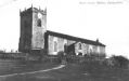
 | MellorMellor has long been known to date back to Saxon and Medieval times - the local church of St. Thomas having the oldest-known pulpit in Britain. During the industrial revolution Mellor was a hive of activity led by William Radcliffe. Today it is much quieter but has a thriving parish centre and strong sense of community spirit. |
|
5 |
456 |
|
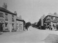
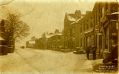
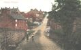
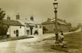
 | Marple BridgeMarple Bridge was already well established in 1795, when it was described as "a small village containing about sixty houses." By this time, it had a corn mill, which formerly stood on the west bank of the Goyt, just to the south of the village, and a water powered forge. The bridge and a reconstructed Town Street are now at the heart of the Marple Bridge Conservation Area. |
|
3 |
329 |
|
 | Hawk GreenHawk Green is an outlying area of Marple, centred around a traditional village green, or recreation ground. There are earlier buildings but most of the housing built up around the Shepley Mill constructed in 1848 on the side of the Macclesfield Canal. The Goyt Mill, constructed in 1905, remains a major landmark in the area today. |
|
2 |
96 |
|
 | StrinesThe Strines area is a beautiful part of the world steeped in history and set in the picturesque Goyt River Valley. There are some very old properties in and around Strines dating back many hundreds of years, however the majority of properties were built after the Printworks was established circa 1790. |
|
1 |
129 |
|
 | CompstallCompstall was formerly a mill village, built by George Andrew in the 1820's to house his 800 workers. Most of the original mill cottages and other structures remain unchanged. The waterways that now form Etherow Park were also constructed by Andrew to carry water from the weir, on the river, to turn the mill wheel, which stood where the car park is today. |
|
1 |
129 |
|
 | High LaneIn the 1800s High Lane had large collieries employing the majority of men in the village and with the coming of the Macclesfield Canal in 1831 it formed a key junction with the main road to Buxton. Windlehurst Mill was built on the bank of the canal in 1872 and later came to an unusual end when it was so badly damaged in gales that it had to be demolished. |
|
1 |
77 |
|
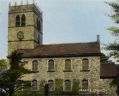
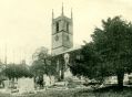
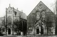
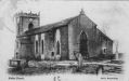
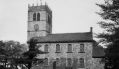 | ChurchesA new series of albums featuring the local churches of Marple and District, including All Saints', Marple; St. Thomas', Mellor; St. Martins, Low Marple; St. Mary's, Marple Bridge and others (this catergory is under reconstruction). |
|
6 |
197 |
|
| Most viewed - Buildings and Street Scenes |

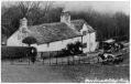
Hill Top Farm3974 viewsHill Top Farm, Hawk Green looks little different today.
|
|

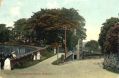
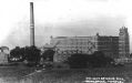
Nab Top Sanatorium3714 viewsNab Top Sanatorium, now Marple Dale Nursing Home. From Marple Local History Society Archives.
|
|

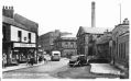
Buxton Road3538 viewsThe bread delivery van makes its way up Buxton Road, High Lane.
|
|

West Towers / Almonds3354 viewsHotel West Towers / Almonds Restaurant makes way for "progress".
|
|

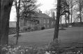
Ernocroft House3343 viewsThe now sadly demolished Ernocroft House, on the Compstall / Marple Bridge border.
|
|

Barnes Fold Cottage3262 viewsBarnes Fold Cottage, built in 1659, from Marple Local History Society Archives.
|
|

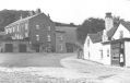
Horseshoe Inn3189 viewsThe Horseshoe Inn and Lower Fold, Marple Bridge.
|
|

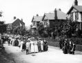
The Crown Pub2997 viewsA large group outside the Crown Public House, probably 1914 - 1918.
|
|
| Random files - Buildings and Street Scenes |

Empress AvenueEmpress Avenue, off Church Lane. From Marple Local History Society Archives.
|
|

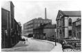
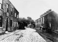
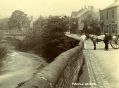
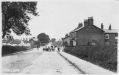
Marple BridgeAnother view down Brabyns Brow towards Marple Bridge that shows why there were so many accidents.
|
|

Mellor Scouts CampingA Mellor Scouts camping trip in the 1930s. Provided by Hilary Ellam to Marple Local History Society Archives.
|
|

Marple Baths c1980Marple Swimming Pool in 1980/81.
Provided by Axel Thomas.
|
|

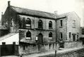
E & E Overalls / E & E WorkwearInside the former Albert Schools building on 28 February 2019, the week before closure for demolition. By Mark Whittaker.
|
|

Chapel House FarmThe Barn of Chapel House Farm, in 1831 this was turned into the first National School in Marple. From Marple Local History Society Archives.
|
|

Dan Bank Road WideningDan Bank in the daytime during the road widening. Taken on 12 February 2011 by Arthur Procter.
|
|

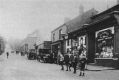
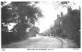
Marple BridgeMarple Bridge, provided by Janet Holmes.
|
|
| Who is online? |
| There are 30 registered users.
The newest registered user is Andre.
In total there are 71 visitors online: 0 registered users and 71 guests.
Most users ever online: 464 on 01/13/23 at 14:51.
Registered users who have been online in the past 10 minutes: . |